
Mitigating Oil Spills in the Niger Delta with Advanced Aerospace Technologies
- Ruth Okoh

- Aug 30, 2025
- 6 min read

The Nigerian oil reserves are primarily located in the Niger Delta, the largest wetland in Sub-Saharan Africa, where fishing and farming are the main sources of livelihood for the majority of its residents. Sadly, it is also the most polluted in the country; persistent oil spill disasters, amounting to losses in billions of dollars annually, pose a serious threat to both the local ecosystem and the broader economy.
From January 2024 to 2025, over 1,050 oil spills were recorded, based on data from the National Oil Spill Monitor.
Oil spills arise from a variety of causes. In some cases, as a result of technical failures, such as tank breakdowns at storage terminals, ruptures along major delivery pipelines, or the corrosion of ageing facilities that have not been properly maintained.
Spills also occur through operational incidents, including oil well blowouts, accidents involving tankers navigating Nigerian waters, or mistakes made by human operators during the handling and marketing of refined products.
Persistent oil spill disasters, amounting to losses in billions of dollars annually, pose a serious threat to both the local ecosystem and the broader economy.
Beyond these, there are deliberate acts such as sabotage and pipeline vandalism, which continue to account for a significant portion of recorded spills across the Niger Delta.
The National Tiered-Response System for Oil Spills
This framework is structured into three tiers, based on the size and location of the incident:
Tier 1 (Small-scale spills): Up to 25 barrels in inland waters or 250 barrels on land or coastal/offshore waters. Responsibility lies with the individual company, which must have its own resources to respond quickly to incidents around its facilities.

Tier 2 (Medium-scale spills): Between 25 to 250 barrels in inland waters or 250 to 2,500 barrels on land or coastal/offshore waters. Companies respond through local cooperatives, sharing access to pooled equipment and joint resources.
Tier 3 (Major spills): More than 250 barrels in inland waters or over 2,500 barrels on land or coastal/offshore waters. Requires national or international support, mobilising advanced equipment, manpower, and expertise.
When oil spills occur in water bodies, the way the slick spreads is determined mainly by the water current, with wind playing a secondary role. The current is always the key factor.
In any spill situation, speed is everything. A fast response can save lives, protect valuable assets, and reduce the overall impact. The real difference lies in how quickly the incident is reported, and how fast response equipment and personnel are mobilised. The sooner the detection, the smaller the spill becomes, the lower the cleanup costs, the less production loss, and the stronger our ability to protect both the environment and national revenue.
The standard procedure for response includes:
● Report: Receive and confirm reports of an oil spill within 24 hours of the incident
● Investigate: Identify the cause of the spill
● Assess: Determine the scale of the spill and the extent of environmental damage
● Respond: Deploy trained personnel and equipment to manage the spill, conduct cleanup, and support rescue operations where necessary in coordination with relevant government agencies
● Restore: Carry out a post-spill survey and begin restoration efforts in collaboration with government agencies and stakeholders
In any spill situation, speed is everything. A fast response can save lives, protect valuable assets, and reduce the overall impact.
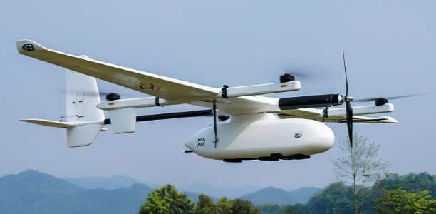
Remote Sensing Drone Applications
Equipped with advanced sensors and cameras, drones quickly survey vast areas, detect spills, cracks, rust, corrosion, or malfunctions with high precision, and provide real-time data to response teams. Their adoption is driving smarter, faster, and safer monitoring of oil and gas assets.

They operate Beyond Visual Line of Sight (BVLOS) and can autonomously follow programmed paths to high-risk or hard-to-reach areas and gather data that feeds into predictive maintenance systems.
Drones for spill detection require specific design and operational considerations;
● Size: Nano (6 inches or less), small (< 12 inches), medium (12 inches – 4 feet), large (4 feet and above)
● Wing/Rotor type: Single-rotor, Multi-rotor, Fixed-wing, Fixed-wing hybrid
● Takeoff and Landing: Vertical (VTOL)
● Power supply: Battery-powered, Gasoline-powered, Hydrogen fuel cell, solar
● Range: Close (1-6 hours), Short (8-12 hours), Mid (24 hours), Long (> 24 hours)
● Payload capacity: featherweight (0.004 to 0.1 kg), lightweight (0.15-0.27 kg), middleweight (0.4-1.46 kg), heavylift (> 1,000 kg)
● Operate at altitudes of 90-100 meters
● Easily operate in complex electromagnetic environments
● Camera fittings (based on mission requirement): LiDAR system, industrial aerial camera, oblique camera system, gimbal system and SAR
Synthetic Aperture Radar (SAR) Satellites
SAR systems simulate a much larger antenna by using the movement of a satellite or aircraft to "synthesise" an aperture, combining multiple radar echoes over time to generate detailed images.
Not hindered by cloud cover or nighttime conditions, Synthetic Aperture Radar (SAR) emits microwave signals towards a target area, penetrating through atmospheric obstructions to capture detailed surface data, and measuring the reflected signals.
When leveraging low-orbit small satellites for video-SAR imaging, a high-resolution SAR sensor capable of operating across multiple microwave frequency bands is ideal.

One drawback of SAR imaging is its pollution with speckle noise, increasing the potential for erroneous interpretations.
However, the integration of AI enhances its effectiveness by automating the analysis of vast amounts of data. Machine learning algorithms, trained on historical spill patterns and environmental conditions, can rapidly identify oil slicks, differentiate them from natural water surface anomalies, and track their movement with high precision.
The Drone SAR system
Drone SAR imaging, which simply involves mounting a miniaturised SAR system on a drone, given the necessary and recent technological advancements in Software Defined Radar (SDR) processing power, enables a lower observation altitude compared to satellites for an improved point density and spatial resolution.
Deployed twice daily through rapid, customisable flight plans; Drone radar systems offer the potential to utilise higher frequency radar bands, and may obtain a line-of-sight (LOS) vector from multiple directions, thus overcoming layover and shadowing effects found in satellite radar data for complex locations.
A comparison of the drone SAR image and Sentinel-1 SAR shows that the former provides an improved centimetric spatial resolution compared to the meter-level resolution of the latter.
While drones excel at close-range inspections of pipelines and offshore facilities, satellite remote sensing provides large-scale, continuous surveillance of expansive areas.

These technologies are scalable and adaptable for managing large infrastructure and pipeline networks, providing thorough, high-quality inspections and notifications in real-time.
An effective Satellite-IoT network
The real power lies in integration. A Satellite Internet of Things (SIoT) network is required in an oil spill contingency plan, as the hub on which all other components rotate.
New specialised sensors being developed are more compact, accurate, and versatile in the detection, measurement, and monitoring of physical, chemical, and biological phenomena.
Laser Rangefinders and gas detecting sensors provide detailed info on the type, thickness and volume of the oil spilled, covert sensors on ground can trigger alarms on tamper/vandalism. Influencing automation with artificial intelligence and predictive analytics, timely alerts are sent to the appropriate teams/authorities.
While drones excel at close-range inspections of pipelines and offshore facilities, satellite remote sensing provides large-scale, continuous surveillance of expansive areas.
Localising technologies for real impact; Capacity-Building Solutions
Spaceboss Aerospace Consulting Ltd provides expert guidance on required drone specifications for oil spill remote sensing/pipeline surveillance and security, ensuring compliance with regulations, and enhancing operational safety. We work with teams/departments to develop customised strategies and training programs.
We collaborate with hardware and software manufacturers, blending innovation, expertise, advanced tools and technologies to develop drone-SAR systems, for improved operational flexibility.
We are committed to providing the highest-quality devices to protect Nigeria’s oil and gas infrastructure, helping secure the nation’s economy and resources.
Conclusion
The National Contingency Plan recognises the need for cooperation among member states of the African sub-region, for combating oil pollution in our connected waters, to strengthen the capacity for national and regional action to prevent, control, combat and mitigate marine pollution, promote technical cooperation, and ensure a coordinated approach to the problem and avoid wasteful duplication of efforts.
As Reseau Associates, we are in a unique position to drive these solutions beyond the talking stage. We have the networks, the skills, and the influence to connect global aerospace technology with African environmental needs. Here’s a call to:
● explore joint pilot projects in oil spill monitoring and rapid response
● create investment pathways that bring these technologies into active use in Nigeria and other African oil-producing regions
● advocate for policy reforms that make aerospace-enabled monitoring a standard industry practice
Oil spill mitigation is just one part of a larger story about how Africa can optimise aerial technologies to protect its natural resources and national security
About the Author
Ruth Okoh is the Founder of Spaceboss Aerospace Consulting Ltd, a private company based in Nigeria, West Africa, offering strategic planning/communications, and Business Development management, to localise innovative aerospace technologies.

Comments